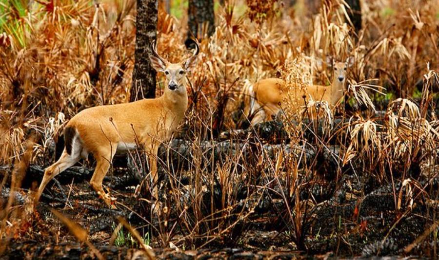
Hunting deer after a wildfire requires you to read the new habitat rather than hunt the area the same way you did before the fire. The most important factors are burn severity, remaining cover, new forage, water, terrain, and fresh deer sign. A burned area is not automatically good deer habitat, and deer do not use every part of a burn equally.
Wildfire can remove bedding cover, expose travel routes, and temporarily push deer into adjacent unburned habitat. As vegetation recovers, the same fire can also create fresh grasses, forbs, shrubs, and browse that provide new feeding opportunities. The result is a patchwork of feeding areas, security cover, travel corridors, and exposed ground. Hunters need to identify how those pieces connect instead of focusing only on the visible burn scar.
Time since the fire also matters. Conditions during the first season can differ substantially from those two or three growing seasons later because forage and cover continue to change as the landscape recovers. This guide explains how to evaluate burn severity, locate productive food-and-cover transitions, identify current deer use, scout the area efficiently, and avoid the most common mistakes when hunting deer after a wildfire.
How Does a Wildfire Change Where Deer Live?
A wildfire changes where deer live by altering four habitat components: food, security cover, travel routes, and access to water. Deer respond to the resulting habitat conditions rather than to the burn itself. Two areas inside the same fire perimeter can therefore receive very different levels of deer use if one retains cover and regenerating forage while the other becomes an exposed landscape with little security.
The first major change is the loss or redistribution of cover. Fire can remove shrubs, young trees, deadfall, and understory vegetation that deer previously used for bedding and concealment. When a heavily burned slope loses most of its vegetation, deer may spend less time there during daylight and shift toward adjacent timber, brush pockets, shaded draws, or other surviving vegetation. A patchy burn can create a different result because burned feeding areas remain close to unburned security cover.
Food availability also changes after fire. Burning removes existing vegetation, but sunlight reaching the ground and reduced competition can support the regeneration of grasses, forbs, shrubs, and other browse. The value of this growth depends on the plant species present, the season, soil moisture, precipitation, and time since the fire. Hunters should therefore evaluate what is actually growing rather than assume that green vegetation automatically provides preferred deer forage.
Wildfire can also change how deer move through a landscape. A trail that previously passed through dense cover may become exposed, while surviving draws, benches, saddles, timber strips, and brush islands can become more important travel features. Terrain itself remains after the vegetation burns, so established topographic funnels can continue to influence movement. The difference is that deer may adjust when and how they use those features according to the amount of security cover left around them.
Water should be evaluated as part of the same habitat system. Springs, creeks, seeps, ponds, and moist drainages can become more important where surrounding vegetation has burned heavily, especially in dry environments. However, finding water alone does not confirm that deer are using the area. A useful location combines accessible water with forage, security cover, favorable terrain, and current deer sign.
Deer may temporarily leave parts of an area during and immediately after a wildfire because of fire activity, smoke, human disturbance, and the sudden loss of habitat structure. Their later use depends on what remains and how vegetation recovers. Some deer may use surviving habitat inside the fire perimeter, while others shift into adjacent unburned areas and return to parts of the burn as food and cover improve.
For this reason, burn boundaries should be treated as habitat mosaics rather than single hunting areas. A hunter should separate the burn into individual units based on severity, vegetation, terrain, forage, and nearby cover. A green drainage bordered by surviving timber has a different hunting value from a large open slope where almost all woody cover was removed.
How Long After a Wildfire Should You Hunt the Burned Area?
There is no single number of months or years that makes a wildfire burn productive for deer hunting. The correct timing depends on how severely the area burned, how quickly forage regenerates, how much cover survived, and whether deer are currently using the habitat. Hunters should judge a burn by its present conditions rather than its age alone.
During the first hunting season after a wildfire, the most important features are usually surviving habitat and early regeneration. Heavily burned ground may contain little security cover, while unburned islands, creek bottoms, timber strips, and partially burned slopes can retain vegetation deer need for bedding and concealment. Fresh plant growth may begin appearing quickly under favorable moisture conditions, but forage recovery does not mean deer will spend daylight hours in an exposed burn.
The first season is therefore a good time to examine the edges of the fire rather than automatically concentrate on its center. For example, a burned opening that produces fresh forage within a short travel distance of dense surviving timber gives deer access to food without requiring them to remain exposed for long periods. A similarly green opening surrounded by hundreds of yards of bare ground may provide food but lack the security conditions needed for consistent daytime use.
One to three growing seasons after a wildfire can produce major habitat changes. Grasses, forbs, shrubs, and woody browse may become more established while deer trails begin reflecting the new distribution of food and cover. At the same time, visibility can remain much greater than it was before the fire. Hunters can use this period to identify locations where regenerating forage overlaps with bedding cover, travel terrain, and fresh sign.
The age of a burn becomes less useful as vegetation continues to recover. An older burn can remain productive when shrubs, young trees, browse, and openings create a varied habitat structure. Another burn of the same age may offer less value because vegetation regenerated poorly, the area became too dense, or preferred forage declined. Vegetation structure is therefore a better hunting indicator than the calendar date of the wildfire.
A practical way to evaluate timing is to compare three conditions. First, determine whether the area currently produces food deer are using. Second, identify whether bedding or escape cover exists within practical travel distance. Third, verify the connection between those resources with fresh tracks, droppings, browsing, beds, or active trails. When all three conditions occur together, the burn deserves closer scouting regardless of whether the fire occurred one year or several years earlier.
Hunters should also account for seasonal changes. A post-fire area that receives heavy deer use while green forage is available may become less attractive after vegetation dries or snow changes access to food. Conversely, a burn that appears unproductive early in the year can become more relevant when seasonal movement places deer near the area. The useful question is therefore not simply “How old is this burn?” but “What does this burn provide deer during the season I intend to hunt?”
How Does Burn Severity Affect Where Deer Use a Burn?
Burn severity affects deer use because it determines how much food, security cover, and vegetation structure remain after a wildfire. A low-severity burn may leave much of the overstory and understory intact, while a high-severity burn can remove nearly all vegetation across a slope. Hunters should therefore evaluate different parts of a burn separately instead of treating the entire fire perimeter as one habitat type.
Low-severity burns can remain useful to deer because they preserve much of the existing cover while creating openings where new vegetation can develop. Trees, shrubs, and ground cover may survive in enough quantity to provide concealment, bedding options, and travel structure. At the same time, small burned patches can receive additional sunlight and produce fresh growth. This combination allows deer to move between food and cover without crossing large areas of exposed terrain.
Moderate-severity burns often create the most varied habitat structure because fire removes vegetation unevenly. A single hillside may contain burned openings, surviving brush, standing timber, partially burned pockets, and new plant growth. This mosaic can place feeding habitat next to security cover, reducing the distance deer must travel between the two. Hunters should pay particular attention to irregular boundaries where surviving vegetation extends into the burn or where small burned openings interrupt larger blocks of cover.
High-severity burns require more careful evaluation. A severely burned area can produce forage without providing enough security cover for consistent deer use. Large sections of bare or lightly vegetated ground expose deer to predators and human activity, especially during daylight. Deer may still enter these areas to feed, but they can spend more time near the perimeter, in drainages, or close to surviving cover rather than bedding in the middle of the burn.
This distinction is important because feeding habitat and bedding habitat serve different functions. A slope covered with fresh forbs may provide excellent food, but deer still need concealment and protection nearby. A hunter who focuses only on green vegetation can therefore overlook the areas where deer spend most of the day. The stronger setup is usually a feeding area connected to security cover by a short, protected travel route.
Burn severity also changes over time as vegetation regenerates. A severely burned slope that is too exposed during the first season may become more useful after shrubs, grasses, and young trees establish. Conversely, a lightly burned area that initially provides a favorable mix of food and cover can lose value if vegetation becomes too dense or preferred forage declines. Hunters should evaluate the current structure of the burn rather than rely only on maps showing the original fire severity.
The most useful way to compare burn severity is to ask three questions: What food is available, how close is secure cover, and is there fresh evidence that deer are using the area? A moderate burn with fresh browse, nearby timber, and active tracks is more valuable than a severe burn that looks green from a distance but contains little cover and no recent sign.
Where Should You Look for Deer After a Wildfire?
There are 6 post-fire habitat features hunters should check first: burn edges, unburned pockets, new forage, drainages, terrain funnels, and water sources. These features matter because they concentrate one or more requirements deer need after a wildfire: food, cover, secure travel, and water.
Are Burn Edges and Unburned Pockets Good Places to Find Deer?
Burn edges and unburned pockets are high-priority scouting areas because they place new feeding opportunities close to surviving security cover. The most useful edges are not necessarily straight lines around the outside of the fire. Irregular boundaries, fingers of surviving timber, brush islands, partially burned draws, and small openings inside otherwise intact cover can create more useful habitat transitions.
A burn edge gives deer access to two habitat types within a short distance. They can feed in regenerating vegetation while remaining close to timber or brush that provides concealment. This relationship becomes especially important in daylight, when deer may avoid crossing large exposed areas. Hunters should examine places where the distance between fresh forage and secure cover is shortest.
Unburned pockets inside a larger burn can become even more important because they provide isolated patches of concealment. A stand of surviving timber, a brushy bench, or a shaded pocket in a drainage may offer bedding cover within an otherwise open landscape. These locations deserve attention when fresh tracks, droppings, beds, or connecting trails show that deer are moving between the pocket and surrounding feeding areas.
The shape of the edge also matters. Points, inside corners, narrow strips of cover, and small openings can naturally concentrate movement because they create limited routes between habitat types. For example, deer traveling from an unburned bedding slope to a burned feeding area may repeatedly use the same timber finger or brush-lined depression rather than cross the widest section of open ground.
Hunters should verify these locations with fresh sign instead of assuming every edge is productive. A sharp boundary between green vegetation and dark timber may look ideal on satellite imagery, but it has little hunting value if deer are not currently using it. Tracks, browsing, droppings, beds, and active trails confirm whether the food-cover relationship is actually influencing movement.
Should You Look for Deer Near New Growth, Water, and Drainages?
New post-fire growth is worth scouting when deer are actively feeding on it and secure cover exists nearby. Wildfire can open the canopy and allow grasses, forbs, shrubs, and woody browse to regenerate, but not every plant species has equal value to deer. Hunters should look for direct evidence of feeding rather than judge a location only by how green it appears.
Browse patterns provide one of the clearest clues. Freshly clipped stems, repeated browsing on the same plant species, tracks around feeding patches, and trails connecting vegetation to cover indicate active use. A broad patch of untouched vegetation is less useful than a smaller area where several signs show deer are feeding consistently.
Drainages can be productive because they often combine several habitat features. Creek bottoms, draws, and moist depressions may retain more vegetation after a fire, support faster regrowth, provide shade, and create protected travel routes. A drainage running through an otherwise open burn can function as a linear strip of cover that allows deer to move between feeding and bedding areas with less exposure.
Water sources deserve attention, especially in dry landscapes, but water should not be evaluated as an isolated attraction. Springs, creeks, seeps, ponds, and other reliable sources become more useful when they occur near food and security cover. A remote water source surrounded by exposed ground can receive less daylight use than a smaller source hidden inside a brushy drainage.
Season and weather also influence the value of these locations. Green growth that attracts deer during a moist period can lose value after drying, while a reliable spring may become increasingly important as surrounding water sources disappear. Hunters should revisit forage and water conditions close to the hunting season instead of assuming scouting observations made months earlier will remain unchanged.
Are Ridges, Saddles, and Travel Corridors Still Important After a Fire?
Ridges, saddles, benches, draws, and other terrain features remain important after a wildfire because fire changes vegetation but does not remove the underlying topography. Deer can modify their routes when cover disappears, but terrain still influences the easiest and safest ways to move across a landscape.
Saddles can continue to provide efficient crossing points between two higher areas. Benches can offer flatter travel routes across steep slopes. Draws can provide concealment and moisture, while ridges can connect feeding and bedding areas across large landscapes. Hunters should examine how the fire changed the vegetation around these features rather than assume the features themselves lost importance.
A terrain funnel becomes more valuable when surviving cover restricts the number of secure routes deer can use. For example, a heavily burned hillside may contain only one brush-filled draw connecting lower feeding habitat with timber above. If fresh tracks and trails confirm repeated use, that draw becomes more significant than a broad open slope where deer could theoretically travel anywhere.
Wildfire can also create new travel patterns. Deer that previously moved through dense timber may shift toward surviving strips of vegetation, shaded drainages, or the backside of ridges after the burn opens the landscape. Comparing old trails with current sign helps determine whether deer retained their previous routes or established new ones.
The strongest post-fire locations usually combine multiple features rather than relying on one. A productive area may contain regenerating forage below a timbered bedding pocket, a drainage providing concealed movement, and a saddle connecting the two. When food, cover, terrain, and fresh sign overlap in the same small area, that location deserves more scouting attention than a visually impressive burn with only one favorable attribute.
How Can You Tell Whether Deer Are Using a Burned Area?
You can confirm deer use in a burned area by finding fresh tracks, droppings, browsed vegetation, active trails, beds, and seasonal rubs. These signs are more reliable than the appearance of the habitat alone. A burn can contain green forage, water, and surviving cover without receiving consistent deer use.
Fresh tracks provide the fastest evidence that deer are moving through a location. Look for tracks in soft soil around creek crossings, springs, muddy edges, ash-covered ground, game trails, and transitions between burned and unburned vegetation. Track freshness matters because old tracks only confirm that deer used the location at some point. Sharp edges, recent soil disturbance, and tracks layered over recent weather effects provide stronger evidence of current activity.
Droppings help confirm how frequently deer use an area. Multiple groups of fresh pellets near feeding cover, trails, or bedding habitat suggest repeated use rather than a single animal passing through. Hunters should compare the condition of different droppings because a mixture of fresh and older sign can indicate that deer have used the same location over an extended period.
Browsed vegetation is especially useful when evaluating post-fire forage. Look for clipped stems, missing leaves, and repeated feeding on the same types of shrubs, forbs, or young growth. A hillside covered with new vegetation can appear attractive but provide little evidence of actual feeding. The presence of preferred forage matters less than proof that deer are currently consuming it.
Active trails can reveal how deer connect feeding and security habitat. The most useful trails often run from regenerating vegetation toward unburned timber, brush pockets, draws, benches, or other concealed terrain. A heavily used trail containing fresh tracks and droppings provides stronger evidence than a faint trail left from before the wildfire.
Beds show where deer feel secure enough to remain for extended periods. Search for flattened vegetation, depressions, hair, droppings, and nearby tracks inside surviving timber, brush patches, shaded slopes, and other protected locations. Bedding sign is particularly valuable because it identifies habitat deer use during periods when they are less likely to remain in exposed feeding areas.
Rubs can add seasonal information where bucks are present, but they should not be treated as year-round evidence. Fresh rubs indicate buck activity during the appropriate part of the season, while old rubs may have little relevance to current deer distribution. Hunters should combine rubs with tracks, droppings, trails, and bedding evidence before deciding that a location deserves hunting pressure.
The strongest evidence comes from several signs occurring together. For example, fresh browse beside a trail leading from an unburned bedding pocket, combined with recent tracks and droppings, indicates a functional connection between food and cover. That evidence is more valuable than finding one isolated track in the middle of an otherwise unused burn.
How Should You Scout a Burn Area Before Deer Season?
Scout a wildfire burn in two stages: first use maps to identify high-probability habitat, then verify those locations on the ground with current deer sign. This approach reduces the amount of terrain you need to cover and prevents you from spending too much time in areas that look promising on a map but lack food, cover, or recent deer activity.
How Can You Scout a Wildfire Burn With Maps?
Use maps to locate places where burned habitat intersects with surviving cover, terrain features, water, and legal access. The goal is not to identify the largest burned area. The goal is to find small sections of the burn where several deer habitat requirements occur close together.
Start with the wildfire perimeter to understand the overall size and shape of the burn. Then compare recent satellite imagery with older imagery, if available, to identify vegetation that survived the fire. Timber strips, unburned islands, brush pockets, creek corridors, and irregular burn boundaries deserve more attention than large uniform areas of exposed ground.
Topographic maps add another layer of information. Mark saddles, benches, draws, creek bottoms, ridgelines, steep slopes, and natural travel corridors. These features help predict how deer may move between feeding and bedding habitat. A narrow draw connecting an unburned ridge with a regenerating slope, for example, provides a more specific scouting target than an entire mountainside.
Water should also be marked before entering the field. Springs, creeks, ponds, seeps, and perennial drainages can narrow the search in dry country. However, water becomes a stronger target when it overlaps with cover and forage. A spring inside a brushy drainage near new growth is generally more informative than an exposed water source surrounded by open burned terrain.
Roads and access points should be evaluated from both a convenience and hunting-pressure perspective. A productive-looking pocket beside an easy road may receive substantial human activity, while similar habitat farther from motorized access may provide more security. Maps showing roads, trails, property boundaries, and public-land ownership can help hunters compare both habitat quality and likely access pressure.
After map scouting, reduce the burn to a small number of priority zones. Strong candidates usually contain at least three components: regenerating food, nearby security cover, and terrain that connects the two. Water and difficult access can further increase the value of a location, but these features should still be verified in the field.
What Should You Check During Ground Scouting?
During ground scouting, check five factors in order: fresh deer sign, current forage, security cover, travel routes, and access conditions. This sequence keeps the scouting process focused on evidence of deer use rather than visual assumptions about the burn.
First, confirm fresh sign. Search soft ground, trail intersections, drainage crossings, feeding areas, and the edges of surviving cover for tracks and droppings. If a location shows no recent sign after a thorough check, its appearance on satellite imagery becomes less important.
Second, examine the current forage. Identify which plants are growing and whether deer are actually browsing them. Look for clipped stems, repeated feeding, fresh tracks around plant patches, and trails connecting the vegetation with nearby cover. The best forage patch is not necessarily the greenest one; it is the one receiving current deer use.
Third, evaluate security cover from the deer’s perspective. Determine whether nearby timber, brush, terrain, or surviving vegetation provides concealment during daylight. Measure the relationship between food and cover rather than evaluating each separately. A feeding area 50 yards from dense cover creates a different movement pattern from one separated from cover by several hundred yards of open ground.
Fourth, identify the routes connecting those resources. Follow active trails where practical and observe whether they pass through draws, saddles, benches, brush strips, or irregular edges. Pay attention to places where several trails converge because these points can reveal consistent travel patterns between feeding and bedding habitat.
Fifth, assess access before deciding how to hunt the location. Determine wind exposure, entry routes, road conditions, terrain difficulty, visibility, and the likelihood of disturbing deer while approaching. A productive location loses much of its practical value if the only access route forces a hunter through the bedding area or across the primary feeding zone.
Use a simple decision framework when comparing locations: food + cover + current sign + terrain + legal access. A site that meets all five conditions deserves priority. A site with excellent forage but no fresh sign should move down the list. A site with strong sign but no practical access may require a different approach or may not be worth hunting at all.
Scouting should continue close enough to the season to reflect current conditions. Post-fire vegetation can change rapidly, water sources can shrink, roads can close, and deer can shift as hunting pressure or seasonal movement changes. The best pre-season information is therefore the most recent reliable evidence of how deer are using the burn.
How Does Hunting Pressure Change Deer Use of a Burned Area?
Hunting pressure can push deer away from exposed portions of a wildfire burn and toward thicker cover, difficult terrain, and less accessible parts of the landscape. Post-fire areas often become easier for hunters to identify because burn perimeters, roads, openings, and vegetation changes are visible on digital maps. When several hunters focus on the same obvious features, deer can adjust where and when they use those areas.
Road access is one of the first factors to evaluate. Firefighting operations may leave roads, dozer lines, or other access routes near the burn, while existing forest roads can make certain edges easy to reach. Easy access does not make an area unproductive, but repeated vehicle traffic, foot traffic, scouting activity, and hunting pressure can reduce daylight deer use near those routes. A feeding area beside a road may still contain tracks and nighttime activity while offering limited opportunities during legal shooting hours.
Deer pressured around open burns can shift toward surviving security cover. Timber pockets, brush-filled draws, steep slopes, unburned islands, and the opposite side of ridges provide places where deer can reduce exposure to hunters. This does not always require a long-distance movement. A deer may only need to move from an open feeding slope into a nearby drainage or timber strip to become substantially harder to see and approach.
Pressure can also change travel routes. A trail that crosses an open burn early in the season may receive less use after repeated human activity. Deer can begin using parallel routes inside thicker vegetation, moving lower through drainages, or crossing open ground later in the day. Hunters should compare fresh sign with earlier scouting observations instead of assuming deer will follow the same route throughout the season.
The best response to hunting pressure is to identify the secure habitat connected to the productive portion of the burn. For example, if several hunters approach a green burn edge from a road below, examine where deer can retreat without abandoning the food source entirely. A brushy sidehill, timbered bench, steep drainage, or inaccessible backside may become more important as pressure increases.
Current sign should determine whether the shift has actually occurred. Fresh tracks appearing deeper in cover, new trails around an exposed opening, or reduced sign near an access route provide evidence that deer have changed their use of the area. Do not assume deer disappeared simply because activity declined in the most visible part of the burn; first check the nearest secure cover and alternative travel routes.
What Are the Most Common Mistakes When Hunting Deer After a Wildfire?
There are 5 common mistakes hunters make when evaluating deer habitat after a wildfire: assuming every burn attracts deer, focusing only on open burned ground, ignoring time since fire, overlooking current deer sign, and treating all burn severities as equal. Each mistake removes an important part of the relationship between food, cover, movement, and security.
The first mistake is assuming every wildfire creates better deer habitat. Fire can stimulate vegetation recovery, but the result depends on burn intensity, precipitation, plant communities, soil conditions, and surviving cover. A burn that produces abundant browse next to timber can become useful feeding habitat, while a large severely burned slope with poor regeneration may provide little immediate value. Judge the vegetation and deer response you can observe rather than the presence of a burn itself.
The second mistake is hunting the most open portion of the burn because it offers the best visibility. Visibility benefits the hunter, but deer still need security. An exposed hillside may contain attractive forage while receiving most of its deer use during low-light or nighttime periods. The stronger hunting location can be the transition where that opening meets brush, timber, a draw, or another concealed travel route.
The third mistake is ignoring how much time has passed since the wildfire. Habitat changes continuously after fire. The first season may be dominated by exposed ground and surviving vegetation, while later seasons can produce more grasses, forbs, shrubs, and young woody growth. A burn should be evaluated by its current vegetation stage, not by the assumption that a certain number of years after fire is always best.
The fourth mistake is relying on habitat appearance without verifying current deer sign. Satellite imagery may show an ideal-looking burn edge, and ground scouting may reveal abundant vegetation, but neither proves that deer are using the location now. Fresh tracks, droppings, browsing, beds, and active trails provide direct evidence. When attractive habitat and current sign disagree, current sign should carry more weight.
The fifth mistake is treating the entire fire perimeter as one habitat type. A single wildfire can contain lightly burned timber, moderately burned mosaics, severely burned openings, untouched islands, creek corridors, and regenerating slopes. Deer can use each part differently. Divide the burn into smaller habitat units and evaluate food, cover, terrain, and sign within each one.
These mistakes share the same underlying problem: judging the wildfire instead of judging deer habitat. The correct question is not whether a location burned, but whether the post-fire landscape currently gives deer the resources and security they need. That distinction keeps scouting focused on measurable habitat conditions rather than assumptions about wildfire.
Read more: Do Deer Eat Ryegrass? Benefits for Deer Food Plots
What Safety Hazards Should You Check Before Hunting a Burn Area?
Check standing dead trees, unstable slopes, loose rock, damaged roads, debris-flow risk, and changing access conditions before entering a wildfire burn. A recently burned landscape can remain physically hazardous after flames and smoke are gone, and those hazards can change after wind, rain, snow, or additional fire activity.
Standing dead trees, commonly called snags, require particular attention. Fire can weaken trunks, roots, and branches without causing a tree to fall immediately. Wind or saturated soil can later bring those trees or large limbs down. Avoid spending unnecessary time beneath visibly damaged trees, especially during strong winds, and evaluate camps, glassing locations, and stationary hunting positions for overhead hazards.
Steep burned slopes can also become unstable because fire removes vegetation that previously helped hold soil and surface material in place. Loose rock, ash, weakened roots, and eroded soil can make climbing or side-hilling more difficult. A route that was easy before the wildfire may no longer be the safest way into the area.
Heavy rain creates another concern in steep burned watersheds. Water can move rapidly across soil with reduced vegetation and carry mud, rock, branches, and other debris into drainages. Low areas, narrow creek bottoms, and canyon routes deserve additional caution when significant rainfall is expected or has recently occurred.
Road conditions may differ from what maps show. Fire, erosion, fallen trees, firefighting equipment, or subsequent storms can damage roads and trails or make them temporarily impassable. Confirm access before relying on a road as the only entry or exit route, especially when hunting remote country.
Visibility can create a separate navigation problem. Burned areas sometimes look open from a distance but contain fallen timber, holes, loose debris, and dense patches of regenerating vegetation. Plan routes using both terrain information and current ground conditions rather than assuming the shortest line across a burn is the safest.
Safety should remain part of the hunting decision rather than an afterthought. A location with excellent deer sign is not a good hunting location when reaching or occupying it exposes the hunter to unacceptable post-fire hazards. Choose an alternative approach or another section of the burn when the terrain cannot be traveled safely.
Can You Hunt an Area That Recently Burned in a Wildfire?
You can hunt a recently burned area only when the hunting season is open, the land is legally accessible, and no wildfire or emergency closure prohibits entry. A valid hunting license or tag does not override a temporary land closure.
Closures can apply to an entire fire area or only to specific roads, trails, campgrounds, drainages, or sections of public land. They can also remain in effect after the wildfire appears extinguished because crews may still be working, roads may be damaged, or falling trees and unstable terrain may remain dangerous. Hunters should confirm the status of the exact parcel they intend to enter rather than assume an old burn perimeter is open.
Check the wildlife agency responsible for hunting regulations in the state or jurisdiction where the hunt takes place. Then verify land access with the agency or land manager responsible for the property, such as the relevant public-land authority, state land agency, county, or private landowner. These checks answer two different questions: whether hunting is legal and whether physical access to that specific land is permitted.
Property boundaries also deserve attention after a wildfire because burned vegetation can remove visual landmarks that previously made boundaries easier to recognize. Fences, signs, roads, and vegetation lines can be damaged or difficult to see. Carry an accurate map and confirm ownership before crossing from public land onto private property.
Road access should be verified separately from general land access. A forest or public-land unit may be open while individual roads remain closed because of repairs, erosion, firefighting operations, or seasonal restrictions. Never assume that an open hunting area guarantees motorized access to the route shown on your map.
Regulations and closures can change between scouting and hunting season. Recheck the official access status shortly before entering the burn, even if the area was open during an earlier scouting trip. This final check protects both legal access and hunter safety while ensuring that a productive post-fire deer location is actually available to hunt.