
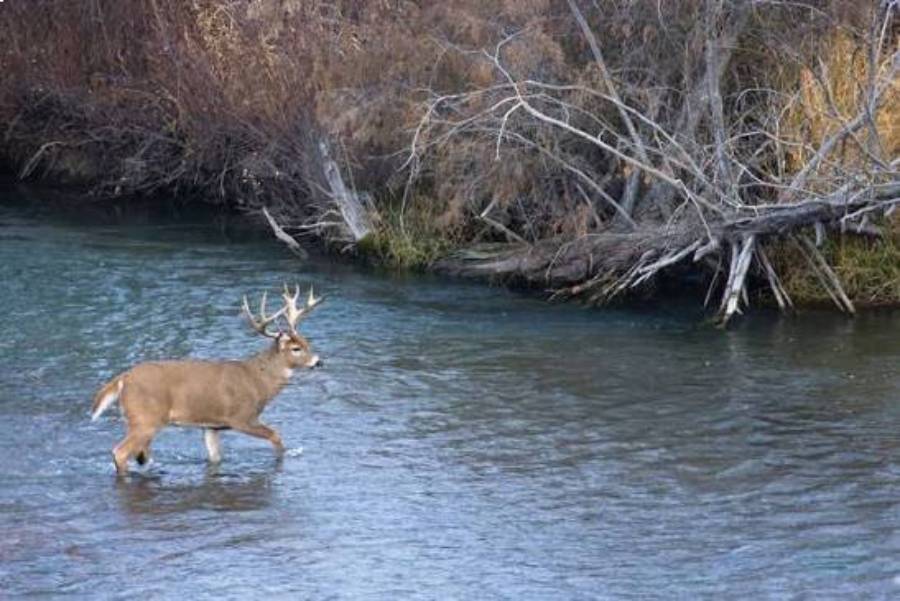
Yes, deer cross rivers. Deer can wade through shallow sections and swim across deeper water when a river lies between their current location and feeding areas, bedding cover, breeding opportunities, or escape routes. A river is therefore not an absolute barrier to deer movement, although water depth, current, bank accessibility, and surrounding terrain can influence where a crossing occurs.
For hunters, the important question is not simply whether deer can cross a river, but where and why they cross it. Deer movement between two useful habitat areas can create recognizable entry and exit points along a riverbank. Tracks, established trails, and fresh sign around these locations can help distinguish an active crossing from a section of river that deer only use occasionally. Seasonal changes, the rut, changing water levels, and hunting pressure can also alter how consistently a crossing is used.
Understanding these patterns makes rivers useful terrain features when scouting deer. This guide explains how deer cross rivers, why they make these movements, where crossings are likely to occur, how to identify an active crossing, and when a river crossing can provide a useful hunting opportunity.
Do Deer Cross Rivers?
Deer cross rivers by either wading through shallow water or swimming when the water becomes too deep to walk through. Rivers can influence the route deer take across a landscape, but water does not automatically stop their movement. A deer can enter the water on one bank, swim across a deeper channel, and climb onto the opposite bank when the terrain provides a usable exit.
The decision to cross is connected to what lies on the other side of the river. A deer may need to reach feeding habitat, bedding cover, breeding opportunities, or another part of its home range. For example, a river separating thick bedding cover from an agricultural feeding area may become part of a travel route rather than functioning strictly as a boundary. The deer does not need to cross at every point along the river; it can use locations that provide a practical route between the two habitat areas.
River conditions affect how deer make these crossings. Shallow sections allow deer to keep their feet on the bottom for longer, while deeper sections require swimming. Current, steep banks, fallen trees, and other physical obstacles can increase the difficulty of entering or leaving the water. As a result, two sections of the same river can present very different crossing conditions.
For hunters, this distinction matters because the ability of deer to cross a river does not mean every section of riverbank is equally useful for scouting. The more valuable locations are crossings connected to actual deer movement. A hunter should therefore evaluate the river together with trails, tracks, surrounding cover, feeding habitat, bedding habitat, and accessible entry and exit points.
How Well Can Deer Swim Across Rivers?
Deer are capable swimmers and can use swimming to cross water that is too deep for them to wade through. This ability means hunters should not automatically treat a deep river as a boundary that deer will never cross. However, swimming ability alone does not establish that deer regularly cross a particular river or use a particular crossing point.
Four physical characteristics are especially relevant when evaluating a potential river crossing: water depth, river width, current, and bank accessibility. Depth determines whether a deer can wade or must swim. Width affects how long it must remain in the water. Current influences the difficulty of maintaining a route across the channel. Bank structure determines whether the deer has a practical place to enter and, more importantly, leave the river.
Bank accessibility can make an otherwise crossable section less useful as a regular travel route. A deer that can physically swim across the channel still needs an exit point on the opposite side. A steep or obstructed bank can make one location less practical than a nearby section with a gradual bank and a trail leading into suitable cover. For scouting purposes, hunters should therefore examine both sides of a suspected crossing rather than judging the location from water depth alone.
The surrounding habitat provides additional context. A manageable river section has greater relevance when it connects places deer have a reason to travel between. For example, an accessible crossing between secure cover and a feeding area has a clearer movement function than an equally accessible section that leads into habitat deer have little reason to visit. The strongest evidence of a useful river crossing is therefore not simply crossable water, but crossable water combined with deer sign and a logical destination on both sides.
Why Do Deer Cross Rivers?
Deer cross rivers primarily because the waterway lies between areas they need to reach as part of their normal movement. A river does not need to be the destination itself. Instead, it can sit between feeding areas, bedding cover, breeding opportunities, or safer habitat, forcing deer to cross the water to continue an established travel route.
Food is one reason a deer may move from one side of a river to the other. Food availability changes across the landscape and throughout the year, so a deer may cross water when a productive feeding area is separated from its daytime cover. Agricultural fields, mast-producing woods, browse, and other seasonal food sources can influence the direction of this movement. In this situation, the river crossing functions as one segment of a larger route between cover and food.
Bedding habitat can create the same pattern in the opposite direction. Deer seek areas that provide security and suitable cover, and those areas may be located across a river from feeding habitat. A deer traveling back toward secure cover may therefore cross the same waterway after leaving a feeding area. For a hunter, examining what lies beyond both banks can provide more useful information than studying the water alone because the surrounding habitat helps explain why the crossing exists.
Breeding activity can also change deer movement. During the rut, bucks may travel beyond their normal movement patterns while searching for receptive does. A river does not necessarily prevent that movement if the animal can cross it. This means a crossing that receives limited use during another part of the season may experience different activity when breeding behavior changes travel patterns. The presence of water alone, however, is not enough to predict increased rut activity; fresh deer sign is still necessary to establish current use.
Danger and disturbance provide another reason for deer to alter their routes. Hunting pressure, human activity, or other disturbances can push deer away from exposed travel corridors and toward different cover. A river may become part of that altered route when crossing it provides access to suitable habitat on the opposite side. Conversely, increased disturbance near an established crossing can reduce its usefulness by causing deer to approach the area differently or use another route.
For hunting purposes, the reason behind a river crossing helps determine its potential value. A crossing that consistently connects bedding and feeding habitat has a different movement context from one created by temporary disturbance. Hunters should identify the habitat connection first, then use tracks and trails to determine whether deer are currently making that movement.
Where Do Deer Usually Cross Rivers?
Deer are more likely to use river crossings that combine manageable water and banks with a practical travel route to useful habitat. The best place to look is therefore not automatically the narrowest or shallowest part of a river. A crossing becomes relevant when its physical characteristics and surrounding terrain work together with the direction deer need to travel.
Accessible banks are one important feature. Deer need a practical way to enter the river and climb out on the opposite side. Gradual banks, openings in dense riverbank vegetation, and unobstructed exit points can provide easier access than steep banks or sections blocked by difficult terrain. A visible trail descending one bank and continuing away from the opposite bank provides stronger evidence than favorable bank structure by itself.
Existing terrain funnels can further concentrate movement. A river may interact with ridges, steep slopes, thick cover, fields, creek mouths, or other landscape features that limit the number of convenient routes available to deer. When terrain naturally directs movement toward a manageable section of river, multiple travel factors can converge at one location. This concentration is particularly relevant to hunters because it can make deer movement easier to identify during scouting.
Water conditions also matter, but they should be interpreted together with the terrain. A shallower section may reduce the amount of swimming required, while slower water can make a crossing less demanding than a nearby section with stronger current. These characteristics make a location physically suitable, but they do not prove that deer use it. A seemingly difficult crossing with established trails and fresh tracks provides stronger evidence of deer movement than an easy crossing with no deer sign.
The habitat on the opposite side provides the final part of the crossing context. A useful deer crossing should lead somewhere deer have a reason to go. Hunters can examine whether the route connects bedding cover, feeding habitat, security cover, or another established travel corridor. Following the movement pattern away from the riverbank can reveal whether the crossing is part of a larger travel route rather than an isolated set of tracks at the water’s edge.
For this reason, hunters should evaluate a potential crossing using three layers of evidence: the physical crossing, deer sign, and the habitat connection. When all three point toward the same movement route, the location provides a stronger basis for further scouting than water depth or river width alone.
Do Deer Use the Same River Crossings Repeatedly?
Deer can use the same river crossings repeatedly when those locations remain part of practical travel routes between important habitat areas. Repeated use is more likely when a crossing provides accessible banks, manageable water conditions, suitable cover, and a direct connection to feeding, bedding, or other frequently used habitat. However, finding evidence that a deer crossed a river once does not prove that the location is a regularly used crossing.
Hunters should distinguish between a possible crossing, an active crossing, and a regularly used crossing. A possible crossing has terrain that allows deer to move through the water but may contain little evidence of actual use. An active crossing has recent sign showing that deer currently move through the location. A regularly used crossing combines fresh sign with an established travel route, such as a defined trail that approaches the river, continues through an entry or exit point, and connects with useful habitat beyond the bank.
Repeated movement can make physical signs easier to identify. Multiple deer traveling along the same route can create a more defined trail through vegetation, while soft mud or exposed soil near the water can preserve tracks. Hunters can also examine whether the trail continues away from both sides of the river. A trail that connects with cover or another established movement corridor provides more context than tracks that disappear immediately after leaving the water.
Crossing use is not permanent. Changes in food availability, water level, cover, breeding behavior, human activity, and hunting pressure can alter deer movement. A route that receives consistent use during one period can become less active after conditions change. For example, deer may adjust their travel when a seasonal food source disappears or when rising water makes an existing entry or exit point more difficult to use.
For this reason, historical deer sign should not be treated as proof of current crossing activity. Hunters should look for fresh evidence and consider when that evidence was created. Combining recent tracks and trails with the surrounding habitat provides a stronger indication of repeated use than relying on an established trail alone.
When Are Deer Most Likely to Cross Rivers?
Deer cross rivers when their movement requires them to reach habitat or resources on the opposite side, so crossing activity changes with daily movement, seasonal habitat use, breeding behavior, water conditions, and hunting pressure. There is no single time that makes every river crossing active because each crossing exists within a different habitat and movement pattern.
Daily movement between bedding and feeding areas can produce recurring river crossings when the two resources are separated by water. In this situation, the important factor is the relationship between the crossing and the deer’s larger travel route. Hunters can examine where the trail leads on each side of the river to determine whether it connects secure cover with a feeding area or another frequently used location.
Seasonal changes can alter that relationship. Food sources become available or disappear, vegetation changes the amount of cover, and deer can shift the areas they use during different parts of the year. A crossing associated with one seasonal food source may therefore receive less traffic after deer begin using another part of their range. Hunters who found a productive crossing earlier in the year should verify fresh sign rather than assume that the same movement continues throughout the season.
The rut can also modify crossing activity because breeding behavior changes how deer move across the landscape. Bucks searching for does may travel through areas differently from their regular feeding-to-bedding patterns. When a river lies within those routes, deer can cross it rather than treating the water as a fixed boundary. Hunters should still use tracks, trails, and other current sign to determine whether a specific crossing is involved in that movement.
Water conditions can change the physical suitability of a crossing. Changes in depth, current, and bank conditions can make an established route easier or more difficult to use. When conditions at one location become unfavorable, deer may use another accessible section rather than follow exactly the same path. This is one reason hunters should scout beyond a single known entry point when crossing activity suddenly declines.
Hunting pressure introduces another variable. Human access, repeated disturbance, and hunting activity can affect how deer use travel routes around a river. Deer may alter their approach, shift toward additional cover, or use another route when disturbance increases around an established crossing. A river crossing should therefore be treated as part of a changing deer movement system rather than a permanent funnel that produces the same activity under every condition.
The practical hunting value of timing comes from combining current conditions with fresh sign. Instead of assuming deer will cross because a location was active previously, hunters can determine whether the crossing still connects habitat deer are currently using and whether recent tracks or trails confirm movement through it.
How Can You Find an Active Deer River Crossing?
You can find an active deer river crossing by identifying fresh deer sign at the water’s edge and confirming that the crossing connects to an established travel route on both sides of the river. Tracks provide useful evidence, but tracks alone do not establish how frequently deer use a location. Hunters should combine tracks, trails, entry and exit points, and surrounding habitat to determine whether a crossing is currently active.
The first place to inspect is the transition between the deer trail and the riverbank. Soft mud, sand, exposed soil, and other surfaces near water can preserve tracks more clearly than hard ground or dense vegetation. Fresh tracks at an entry point indicate recent deer presence, while tracks on the opposite bank help confirm that deer actually crossed the river rather than simply approached the water. Multiple tracks can provide additional evidence, although hunters should avoid assuming that every visible track was made during the same crossing period.
A defined trail leading toward the river provides stronger context. Repeated travel can create a recognizable path through grass, brush, leaves, or other vegetation. Hunters should determine whether that trail terminates at the water or continues from an exit point on the opposite bank. A trail that approaches the river, crosses at an accessible location, and continues into useful deer habitat provides stronger evidence of an established crossing than isolated tracks along the shoreline.
Entry and exit points can also reveal how deer interact with the terrain. Look for locations where the bank allows practical access to the water and where trails converge near the shoreline. An apparent entry point becomes more significant when a corresponding exit exists across the river. The relationship between the two points can help a hunter reconstruct the direction of travel and determine how the crossing fits into the surrounding terrain.
What Signs Show That Deer Are Using a River Crossing?
The strongest signs of deer using a river crossing are fresh tracks, established trails, identifiable entry and exit points, and deer sign that continues away from the river. These signs become more useful when several occur at the same location because each provides a different piece of evidence about the movement route.
Tracks confirm deer presence, while trails provide information about repeated movement. A clear trail through vegetation can indicate that animals have traveled the route more than once, but its existence does not establish that the route is active today. Hunters should therefore examine the trail for newer evidence, including recent tracks or freshly disturbed vegetation where ground conditions allow these signs to be identified.
The direction of the trail also matters. Follow the route visually beyond the immediate riverbank and determine what habitat it connects to. A crossing becomes more meaningful when the trail leads toward bedding cover, feeding habitat, thick security cover, or another travel corridor. This broader terrain relationship helps explain why deer would repeatedly use that section of the river.
Hunters should also examine both banks whenever access and local regulations allow it. Evidence on only one side can be misleading because deer may travel parallel to a river, approach it to drink, or turn before entering the water. Matching entry and exit routes provide stronger evidence that the location functions as an actual river crossing.
How Can You Tell Whether a Deer Crossing Is Still Active?
A deer crossing is more likely to be active when recent sign overlaps an established route. An old trail shows that deer have used the location historically, while fresh tracks and other recent disturbance indicate that the route remains part of current movement. Hunters need both types of information when evaluating whether a crossing deserves further attention.
Freshness should be judged in relation to local conditions. Rain, rising water, wind, falling leaves, and changes in soil conditions can erase or obscure sign, while sheltered tracks can remain visible longer. For this reason, the appearance of a track should not be treated as a precise clock. A better approach is to compare different signs at the location and consider recent weather and water conditions.
Repeated scouting can provide additional evidence. If fresh tracks appear again after previous sign has been erased by rain or changing conditions, the location provides stronger evidence of continued use. Trail cameras may also help monitor movement where their use is legal and permitted by the landowner or applicable hunting regulations. They can show whether deer are actually passing through the crossing area and whether movement occurs consistently enough to influence a hunting setup.
Finally, hunters should check whether the habitat connection that originally made the crossing useful still exists. Food availability, cover, water level, hunting pressure, and seasonal movement can change the route deer choose. An active deer river crossing is therefore identified by the combination of a usable crossing, a logical habitat connection, and current deer sign—not by any single track or trail.
Read more: Can Deer See Green Light at Night? Deer Vision Guide
Are River Crossings Good Places to Hunt Deer?
Active river crossings can be good places to hunt deer when they concentrate predictable movement between habitat areas, but a river crossing is not automatically a good hunting location. Its value depends on how frequently deer use the route, what habitat the crossing connects, how deer approach it, and whether a hunter can access the area without disrupting that movement.
A crossing becomes more relevant when terrain limits the number of practical routes available to deer. Accessible banks, surrounding cover, steep terrain, and established trails can direct movement toward a particular section of river. When fresh sign confirms that deer repeatedly use this route, the crossing can function as a movement funnel. Hunters can then evaluate how deer enter and leave the area rather than treating the entire riverbank as equally productive.
The habitat connected to the crossing is equally important. A river crossing between bedding cover and a feeding area has a clear function within deer movement. A crossing that connects two sections of secure cover may serve a different purpose. Identifying this relationship helps explain where deer are coming from and where they are going, which provides more useful hunting information than simply knowing that deer have crossed the river.
Hunters should also determine whether movement is consistent enough to justify a setup. One set of tracks proves deer presence but does not establish a predictable travel pattern. An established trail combined with fresh tracks, repeated sign, and a logical habitat connection provides stronger evidence. If scouting shows that deer have stopped using the crossing after a change in water level, food availability, or hunting pressure, its previous activity should not be used as the sole reason to hunt there.
Wind and access can reduce the value of an otherwise active crossing. A hunter who must walk through the primary deer trail, cross a bedding area, or approach from a direction that carries scent toward incoming deer can disturb the movement being targeted. The best hunting location may therefore be away from the water itself, where the hunter can intercept the travel route while maintaining a lower-impact access path.
The hunting value of a river crossing comes from predictable deer movement, not from the presence of water. Hunters should use the river as one piece of terrain information and confirm its importance through current deer sign, habitat connections, wind, and access conditions.
Should You Hunt Directly on a Deer River Crossing?
You should not automatically hunt directly on a deer river crossing because the crossing point and the best hunting position can be two different locations. The crossing identifies where deer move through the river, while the hunting position needs to account for wind direction, access, cover, visibility, and the route deer use before and after reaching the water.
Setting up directly beside the crossing can place a hunter close to concentrated movement, but proximity also increases the chance of disturbance. Walking along the same trail deer use, leaving scent around the entry point, or repeatedly entering a small crossing area can affect how deer approach the location. A setup positioned away from the immediate riverbank may allow the hunter to target the same travel route without occupying its most concentrated point.
Wind direction should be evaluated in relation to the expected approach route. Knowing where deer enter the river is only part of the setup. Hunters should determine which side the deer are expected to approach from and where their trail continues after leaving the water. A stand or ground position should then be selected so that the prevailing wind does not consistently carry human scent toward the anticipated movement route.
Access deserves the same attention. A productive stand location loses value when reaching it requires disturbing the deer the hunter intends to intercept. For example, a position close to a crossing may appear ideal from a map, but an approach route that passes through nearby bedding cover can create unnecessary disturbance before the hunt begins. A location farther along the travel corridor may provide cleaner access while still intercepting deer associated with the crossing.
Cover and visibility determine where along that route a practical setup exists. Dense riverbank vegetation can conceal deer movement but may also limit visibility, while open banks can expose both deer and hunters. Rather than assuming the water’s edge is the correct location, hunters should examine the trail leading toward and away from the crossing for positions that provide usable cover and an appropriate shooting opportunity within legal and ethical hunting conditions.
Hunting pressure can further change the decision. Repeated activity around an obvious crossing may alter deer movement, especially when alternative routes exist nearby. Hunters should continue checking fresh sign instead of assuming deer will always return to the same point. A decline in recent tracks or a shift toward another trail can indicate that the movement pattern has changed.
Treat the river crossing as a scouting clue rather than a predetermined stand location. First confirm that deer are currently using it, determine what habitat the route connects, identify the direction of travel, and then select a hunting position based on wind, access, cover, and current deer movement.